#SevereWeather #AtmosphericRiver
From CNN.com: This notorious West Coast phenomenon fueled historic floods in the East. Another one is on the way
https://www.cnn.com/2025/04/18/weather/kentucky-floods-atmospheric-river-climate?cid=ios_app

#SevereWeather #AtmosphericRiver
From CNN.com: This notorious West Coast phenomenon fueled historic floods in the East. Another one is on the way
https://www.cnn.com/2025/04/18/weather/kentucky-floods-atmospheric-river-climate?cid=ios_app
Mesoscale Precipitation Discussion 0059
NWS Weather Prediction Center College Park MD
1005 PM EDT Wed Mar 12 2025
Areas affected...portions of southern California
Concerning...Heavy rainfall
Valid 130205Z - 131405Z
Summary...A frontal band will translate from west to east across
southern California coastal ranges, resulting in 1-2 inch rainfall totals - highest in terrain-favored areas. This rainfall will
affect burn scars across the region, posing a risk of runoff,
flash flooding, and debris flows through at least 13Z/6a PDT.
(More)
https://www.wpc.ncep.noaa.gov/metwatch/metwatch_mpd_multi.php?md=0059
Great weather overview on what to expect from the incoming California atmospheric river from @SeattleWXGuy @seattlewxguy.bsky.social
Well worth a watch!
Significant number of winter weather warnings/watches in the mountains, flood warnings at lower elevations. #CAwx #rain #AtmosphericRiver
Birds waiting for the atmospheric river to roll in. My new earworm is "Birdies On The Storm" by The Doors.
Oooh, grainy picture of a swirling thing in the atmosphere off the coast of California!
(not here yet, it's rather warm out and sunny. I have to bicycle to the grocery store before it starts raining.)
Computer models say, YES, Atmospheric River inbound on Wednesday to Santa Barbara/Ventura/Los Angeles/San Diego. #CAwx #rain #AtmosphericRiver
Possible atmospheric river all the way to Los Angeles county this week. We can use it.
Incoming atmospheric river for Washington and Oregon #WAwx #ORwx #rain #AtmosphericRiver
https://www.wpc.ncep.noaa.gov/metwatch/metwatch_mpd_multi.php?md=0050
Hey, #PNW - Keep your eye on the prize.
One more #AtmosphericRiver to go.
Just hang on until Wednesday.
#WAwx #seattle
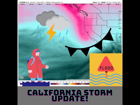
#Mudslides, 126-mph winds and feet of snow pummel #California amid #AtmosphericRiver
The biggest storm so far this winter blasted California with #flooding #downpours, #hurricane-force winds and feet of #snow in the mountains. Some of the worst damage occurred near the #BurnScars from January's deadly #fires.
By Brian Lada, AccuWeather meteorologist and senior content editor
Published Feb 14, 2025
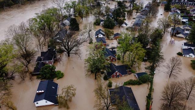
"Mudslides, flooding downpours and feet of mountain snow were unleashed across California as the biggest storm so far this winter hit the state, including areas devastated by deadly #wildfires in January.
"Evacuations were ordered and roads were shut down near the burn scars of the #PalisadesFire and the #EatonFire due to the risk of mudslides, flash flooding and debris flows, including a stretch of the #PacificCoastHighway between #Malibu and #SantaMonica.
"A person with the Los Angeles Fire Department was swept away in a vehicle amid the flooding but managed to escape with only minor injuries, according to The Associated Press.
"Bulldozers were needed to clear feet of mud, rock and debris from some roads as the heavy rain ran off the charred mountainsides.
"'Over 10 inches of rain fell in some areas, including 10.87 at Manchester, on the coast west of #Sacramento, and 9.89 inches at Mining Ridge, 90 miles south of #SanJose,' AccuWeather Meteorologist and Digital Producer Jesse Ferrell said.
"Rain even fell in California's #DeathValley National Park, with 0.18 of an inch falling in the hottest place in North America. In an entire year, the remote park typically measures 2.20 inches of rain."
Read more:
https://www.accuweather.com/en/winter-weather/mudslides-126-mph-winds-and-feet-of-snow-pummel-california-amid-atmospheric-river/1745097#google_vignette
#ClimateCrisis #ClimateThreats #ClimateCatastrophe #ExtremeWeather #Polycrisis
#ForkedMeadow #California received around 8-8.5 inches of precipitation with the #atmosphericRiver that just finished up. There's about a foot of snow on the ground from the tail end of the storm.
That puts us up to about 27 or 28 inches for the water year. We need at least 35 inches to have an average year and we really need at least 45 inches to make a dent in the water deficit from the drought.
Absolutely fucking pouring in #VanNuysCA lol. #CAwx #SoCalwx #rain #atmosphericriver
It's torrential in my part of Ventura County at 3:20pm. #CAwx #rain #AtmosphericRiver
#ForkedMeadow #California has received about 6 inches of precipitation today so far. At one point it was raining at the rate of a half an inch an hour which is incredibly heavy for there.
It has been switching back and forth between heavy snow and heavy rain all day. Currently the creeks are at the tops of their banks and will soon overflow. The temperature is 36f at the moment but it keeps swinging between the freezing point and 37f.
Info on #DebrisFlow cameras. Snipped from FB. #AtmosphericRiver #CAwx
"Update: all seven new cameras are now online
With a major atmospheric river projected to hit Southern California this week, ALERTCalifornia's field team has been working hard to install seven new cameras around Los Angeles to help emergency managers monitor potential debris flows from the Eaton and Palisades burn scars. The Bailey Canyon 1 & 2, Sierra Madre Canyon 1 & 2, and Sierra Madre Bridge cameras are already online for the the Eaton Fire scar. Cloudcroft 1 & 2 cameras will be online soon for the Palisades Fire scar. Search camera names at cameras.alertcalifornia.org to see their locations."
When this map opens it is centered on the #EatonFire area and shows the drainage ways with a black dot at the low end of each one. The map also shows the weather radar with yellow areas indicating heavier rain than green areas.
There is concern that heavy rains may cause #DebrisFlow
You can drag the map over to the area of the #PalisadesFire and see the same thing.
#AtmosphericRiver #CAwx
The colors on this map always show an estimate from NOAA of the rainfall expected over the next 5 days. As is typical, south facing slopes are expected to receive increased rain.
The map also shows pink shading for recent fire perimeters including for the #EatonFire and #PalisadesFire where there is at least some #DebrisFlow risk.
#AtmosphericRiver #CAwx
Thursday looks wet... (probably a good thing) #rain #AtmosphericRiver #CAwx #SanDiego #LosAngeles
#California #AtmosphericRiver #DebrisFlow
From Los Angeles Times: Powerful new rainstorm brings risk of debris flows to L.A. fire zones this week